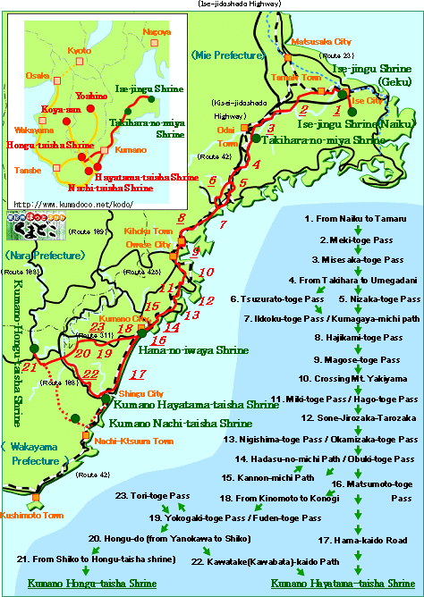
From Naiku to Tamaru trail (about 14km and 4hrs. walk)
 |
From Ise-jingu Shrine(Ise City) to Tamaru(Tamaki-cho town), where is the
starting point of Kumano Kodo(old Kumano-kaido road). Through this trail
you walk on paved raod, but you can enjoy history of Ise City by shrines
and temples on the roadside. Relatively long distance, but easy hiking
course with some gentle slope.
---For More Details, click Here ! |
| |
|
Meki-toge Pass trail (about 16km and 5hrs. walk) |
Meki-toge Pass is small and short pass with gentle slope. This pass consists of "Senmaigan"(a kind of metamorphic rock), which is typical of this pass.
There are many old guideposts and temples in this trail, so you can enjoy
atmosphere of old Kumano-kaido road. Relatively long distance, but easy
hiking trail.
---For More Details, click Here ! |
| |
|
Misesaka-toge Pass trail (about 21km and 6.5hrs. walk) |
Misesaka-toge Pass isn't so hard with short steep slope, but long distance
with some uphill and downhill makes this trail reratively hard.
After the pass you reach Takihara-no-miya Shrine, which is strong connection
with Ise-jingu Shrine.
---For More Details, click Here ! |
| |
|
From Takihara to Umegadani trail (about 18km and 5.5hrs. walk) |
Along Ouchiyama-gawa River and Route 42, you have to walk on paved road
through most of this trail. Because there is no pass in this trail, easy
hiking trail in spite of long distance.
---For More Details, click Here ! |
| |
|
Nizaka-toge Pass trail (about 11km and 3.5hrs. walk) |
This pass became one of the official routes near the beginning of Edo period.
This hiking trail is suitable for beginners and has many untouched
forests and an enjoyable variety of plants.
---For More Details, click Here ! |
| |
| Tsuzurato-toge Pass trail (about 13km and 5hrs. walk) |
It used to be a pass bordering Ise and Kii. It was still used as a road
after the completion of Nisaka-toge Pass. This hiking trail is also suitable
for beginners and has wonderful scenery from the top. ( It's harder if
you start from the Kiinagashima side.)
---For More Details, click Here ! |
| |
Ikkoku-toge Pass/Kumagaya-michi Path trail
(about 8km and 2.5-3hrs. walk) |
It's a flat trail overlooking Kiinagashima
Town. It has no stone paths, but enjoyable cypress forests,
ocean vistas, and views of the town.
Best for beginners.
---For More Details, click Here ! |
| |
| Hajikami-toge Pass trail (about 14km and 4.4hrs. walk) |
It's a pass located on the border of Kiinaagshima
Town and Miyama Town. There are no difficult slopes and anybody
can enjoy this hiking trail.
---For More Details, click Here ! |
| |
|
Magose-toge Pass trail (about 11.5km and 4.5hrs. walk) |
It's a pass located on the border of Miyama
Town and Owase City. This trail has the most beautiful stone
paths in Kumano Kodo and also has a maintained hiking trail
leading to Mt.Tengura . For beginners.
---For More Details, click Here ! |
| |
| Crossing Mt.Yaki-yama trail (about 12km and 4.7hrs. walk) |
"Crossing Mt. Yaki-yama" is used to be called " The hardest
point in the west Japan". It's the most rugged trail and requires
a certain strength to walk. However, you appreciate not only the hardness,
but also great landscapes from the top.
---For More Details, click Here ! |
| |
|
Miki-toge Pass/Hago-toge Pass trail (about 6km and 3hrs. walk) |
This trail runs from Mikisato-cho(Owase), through to Kaga-cho(Owase). It
was recently found and the old roads are broken in some places, connected
now by paved roads.
Anybody can enjoy this trail and be charmed by the extremely
long boar fence.
---For More Details, click Here ! |
| |
|
Sone-Jirozaka-Tarozaka trail (about 5km and 2.5hrs. walk) |
This trail is to get over Hobo-toge Pass which used to be the boundary between Shima Country and Kii Country. You get to Nigishima-cho, it's a part of Kumano city. Some good stone paths through beautiful Japanese cypress forests, tombstones of pilgrims, you can enjoy typical "Ise-ji Route."
If you like, you can go to "Tategasaki," a big wall of rock, by ship from Sone-cho or Nigishima-cho. (Reservation is required.)
---For More Details, click Here ! |
| |
Nigishima-toge Pass/Okamizaka-toge Pass trail
(about 4.5km and 2.5hrs. walk) |
This trail leads from Nikishima-cho in Kumano to Atashika-cho which is
famous for its beautiful beach. Through most of this trail, there is stone
path in Japanese cedar or cypress forests. You can enjoy the typical atmosphere
of "Ise-ji Route," such as stone paths and boar fences.
---For More Details, click Here ! |
| |
Hadasu-no-michi Path/Obuki-toge Pass trail
(about 5km and 3hrs. walk) |
In Hadasu there is the oldest stone path in this area, it seems to be constructed
in Kamakura era (1185-1333). And it is said that "Jofuku," an
ancient Chinese, was washed ashore here looking for an elixir of life.
So there is "Jofuku-no-miya Shrine" in Hadasu. Around Obuki-toge
pass, there is beautiful bamboo forest.
Through this trial there are gentle slopes, you can enjoy hiking with nice
view of Kumano-nada sea.
---For More Details, click Here ! |
| |
Matsumoto-toge Pass & Hanano-iwaya Shrine trail
(about 5km and 3hrs. walk) |
This trail is one of the most popular trails in "Ise-ji Route"
with good stone paths, nice view from the summit of Oni-ga-jo castle, Shishi-iwa
Rock, Hanano-iwaya Shrine, and so on. Every one enjoy this trail.
---For More Details, click Here ! |
| |
|
Kannon-michi Path trail (about 4.7km and 3hrs. walk) |
This trail connects Hadasu and Odomari in
Kumano City. You can find your favorite Kannon statue(the Goddess
of Mercy) on the way, walking the paths watched by the goddess
herself. The trail itself is short and easy. You may try this
trail along with Obuki Toge.
---For More Details, click Here ! |
| |
Hama-kaido Road trail (North & South)
(about 12.2km and 4hrs. walk & about 14.4km and 5hrs. walk) |
This course leads to Shingu from the urban district of Kumano, along the
Shichiri-mihama Beach. It's a flat walking along the coast and has no passes.
The destination is "Kumano Hayatama-taisha Shrine."
It may be hard to walk from Kumano to Shingu in one stretch. If you divide
this trail into 2 courses, it will be enjoyable for everyone.
---For More Details, click Here ! |
| |
| From Kinomoto to Konogi path (about 10km and 3.4hrs. walk) |
Kumano Kodo is divided into two route in Kumano city, "Hongu-do Road"
leading to "Hongu-taisha Shrine" and "Hama-kaido Road"
leading to "Hayatama-taisha Shrine." This path is a part of "Hongu-do
Road" leading to Yokogaki-toge Pass.
You can enjoy easy hiking with historic sites along this path, all of which
consists of paved road.
---For More Details, click Here ! |
| |
Yokogaki-toge Pass/ Fuden-toge Pass trail
(about 5.5km and 2.4hrs. walk & about 4km and 1.9hrs. walk) |
These passes are a part of "Hongu-do Road." Both passes have
no sharp slope, so they are easy hiking trail. Also there is beautiful
stone paths in both pass.
---For More Details, click Here ! |
| |
Hongu-do trail (From Yanokawa to Yoji, Shiko)
(about 19km and 7.5hrs. walk) |
After Huden-toge Pass, Kumano Kodo lasts to Yoji-no-watashi Ferry at Kumano-gawa
River. At the ferry pilgrims crossed the river and reached Shiko.
While walking through mountains in Kumano City, you can enjoy some ancient
road and historic sites. Long distance with lasting up-and-down slope makes
this trail hard.
---For More Details, click Here ! |
| |
From Shiko to Hongu-taisha Shrine trail
(about 14km and 5hrs. walk) |
After crossing Kumano-gawa River, pilgrims go over Banze-toge Pass and
joined Kokumotori-koe, a part of "Nakahe-chi Route," and reached
Hongu-taisha Shrine, one of the destinations of pilgrims. This trail is
the very part of it.
---For More Details, click Here ! |
| |
| Tori-toge Pass trail (about 5km and 2hrs. walk) |
At the end of Fuden-toge Pass, Route is devided into two, one is "Hongu-do"
leading to "Hongu-taisha Shrine," the other is "Kitayama-michi"
leading to Yoshino. Tori-toge Pass is a part of "Kitayama-michi."
Since the pass itself is very short, it is recommended to enjoy this hike
along with "Maruyama Senmaida rice field". You can even get there
by car.
---For More Details, click Here ! |