|
|
 |

|
|
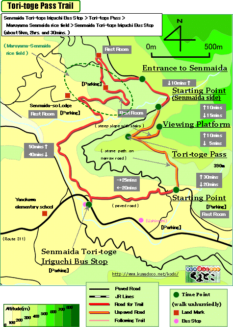
About 5km, About 2hrs.: Round trip from/to Senmaida Tori-toge Iriguchi
Bus Stop
--- easy walk |
|
|
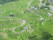
| This trail isn't a part of the World Heritage, but good stone paths are
remainig from starting point to Tori-toge Pass and "Maruyama Senmaida
rice field" is so unique scenery - thousands of rice field are on
steep slope. |
| "Tori-toge Pass trail" brief Map |
|
 click a map and you can see a big PDF map for printing click a map and you can see a big PDF map for printing |
|
| Senmaida-Toritoge Iriguchi Bus Stop ->(slight uphill, paved road, 25mins.)-> Starting Point ->(uphill, stone path, 30mins.)-> Tori-toge Pass ->(steep uphill, unpaved road, 10mins.)-> Viewing Platform ->(steep downhill, unpaved road, 5mins.)-> Tori-toge Pass ->(downhill, unpaved road, 10mins.)-> Starting Point(senmaida side) ->(even, paved road, 10mins.)-> Entrance to Senmaida ->(downhill, paved road, 40mins.)-> Senmaida-Toritoge Iriguchi Bus Stop |
|
|
| by car |
Nagoya ==(Highway & Route 42 / 4hrs.)== Kumano-shi Station ==(Route42
& 311/40mins.)== Senmaida-Toritoge Iriguchi Bus Stop |
| by train and bus |
Nagoya Station ==(Nanki Express / 2hrs. and 50mins.)== Kumano-shi Station
==(Local Bus/ 40mins.)== Senmaida-Toritoge Iriguchi Bus Stop |
|
|
|
 |