|
|
 |

|
|
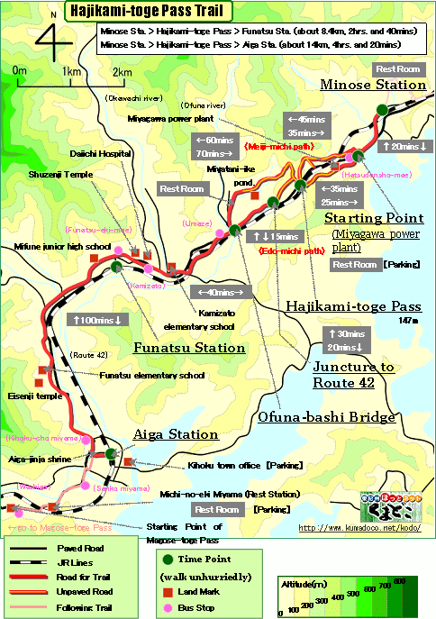
About 14km, About 4hrs. and 20mins.: From Minose Station to Aiga Station
--- Easy walk (There are two paths, Edo-michi Path and Meiji-michi Path.
Each one is easy.) |
|
|
Hajikami-toge Pass is the boundary between Kii-Nagashima area and Miyama
area.
In this trail, there is two paths, Edo-michi Path and Meiji-michi Path,
and Edo-michi Path is a part of the world heritage. And many part of Edo-michi
Path was reconstructed by the local community "Miura-Arukou-kai"
in 1998-1999.
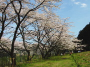
Grass field of Miyagawa-daini-hatsudensyo Power Station, it's near the
starting point of Edo-michi Path, is famous for cherry blossoms.
You can enjoy a good view on the summit of this pass, where a famous travel
writer Suzuki Bokushi made the Haiku. |
| "Hajikami-toge Pass Trail" brief Map |
|
 click a map and you can see a big PDF map for printing click a map and you can see a big PDF map for printing |
|
| Minose Station ->(even, paved road, 25mins)-> Starting Point ->(by Edo-michi path, even-uphill, unpaved road, 30mins.)-> Hajikami-toge Pass ->(by edo-michi path, downhill, mostly unpaved road, 10mins.)->
Juncture to Route42 ->(downhill, paved road, 10mins.)-> Ofuna-bashi Bridge ->(even, paved road, 40mins.)-> Funatsu Station ->(even, paved road, 100mins.)-> Aiga Statino |
|
|
| by car |
Nagoya ==(Highway & Route 42 / 2hrs. and 50mins.)== Minose Station ==(Route 42 / 15mins.)== Aiga Station |
| by train |
Nagoya Station ==(Nanki Express / 2hrs.)== Kii-Nagashima Station ==(Local
/ 10mins.)== Minose Station ==(Local / 10mins.)== Funatsu Station ==(Local
/ 5mins.)== Aiga Station |
|
|
|
 |